Boulevard Oaks Houston Neighborhood Maps
Navigate the new Boulevard Oaks maps. Read about the Boulevard Oaks neighborhood and its real estate guide. Explore map of Boulevard Oaks homes for sale.
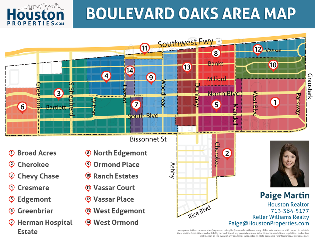
Boulevard Oaks is an architecturally diverse neighborhood of 21 subdivisions lined by oak trees. Boulevard Oaks homes for sale are a mix of beautiful 1920s and 1930’s era homes, with a few modern-styled homes.
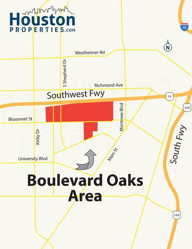
Located north of Rice University, Boulevard Oaks lies between the Southwest Freeway to the north, Morningside to the west, Bissonnet to the south, and Graustark/Parkway to the east.
Boulevard Houston Related Resources:
Two New Boulevard Oaks Houston Neighborhood Maps
"Every single member of the Houston Properties Team was a delight to work with. They are always available, attentive, and active in the pursuit of the right buyer. Their advice was spot-on and helped us sell our home in just 5 days. Best of all, when it really mattered, they bent over backward to ensure an easy closing. We cannot thank them enough. If you want a smart team with a solid understanding of the market on your side, I recommend you hire the Houston Properties Team – they won't let you down.” – Linda Chang
Table of Contents
- Boulevard Oaks Maps: Neighborhood
- Boulevard Oaks Houston: Subdivisions
- The Best Houston Realtor to Sell Your Home
Boulevard Oaks Maps: Neighborhood
For details on any specific property in the Boulevard Oaks area, please contact Paige Martin, ranked #1 Individual Agent with Keller Williams in Houston. Email at [email protected] or call 713-425-4194.
The Boulevard Oaks neighborhood features approximately 1,200 homes. Boulevard Oaks homes for sale include Tudor revival, Colonial revival, Italian renaissance, Spanish eclectic, French manorial, Neoclassical, post-war ranch, and English Picturesque.
Lot sizes are generally larger than its Inner Loop neighbors, and it’s not common to see wall-to-wall homes in the area. Home prices range from around $600,000 to nearly $5,000,000.
Turnover of homes in Boulevard Oaks is low due to lack of inventory and high demand. More than 24% of residents have resided in the area for more than five years.
Residents are very protective of the neighborhood’s old-world charm. The community prefers restoring old homes and has even protested the tearing down of old buildings to make way for high rises. However, this has not affected the sales in the area. Boulevard Oaks continues to exhibit a strong appreciation trend.
Nearby neighborhoods include Upper Kirby, West University, Midtown, Montrose, Downtown Houston, Museum District, and Medical Center. (Check the Boulevard Oaks Houston map above)
Boulevard Oaks Houston: Subdivisions
“Paige and her team are knowledgeable, attentive, responsive, and patient. The HoustonProperties.com team put us into our first dream home, and due to that experience, we’ve returned to them time and again for our real estate needs. While the team’s focus is on completing your deal, their endgame is to ensure your needs are preserved and satisfied.” – Peter McGillivray & Jillian Jopling
There are a total of 21 subdivisions under Boulevard Oaks.
Boulevard Oaks development began in the 1920s to early 1930s. Subdivisions of Broadacres, Edgemont, and Ormond Place were the first ones to emerge.
In 1924, West Edgemont started development, followed by West Ormond Place, Chevy Chase, and Vassar Place. From 1930 to 1940, real estate developers began developing other nearby subdivisions.
The following is a list of these subdivisions and their boundaries:
Broadacres – from 1300 to 1506 North Boulevard
Cherokee – 5300 Cherokee & 5300 Mandell
Chevy Chase – 2000 – 2200 blocks South, 2100 – 2200 blocks North Blvd., 2100-2200 blocks Bartlett, 2100-2200 blocks Banks, 2100-2200 blocks Milford, 2203-2207 Milford, 1931 & 1932 South Blvd., 1931 North Blvd.
Cresmere/West Ormond Place – 1921 – 1932 Banks, 2000 blk Banks, 1921 – 1932 Milford, 2000 Milford, 2000 North, 1930-1924 North Blvd.
Edgemont – 1512 – 1728 North Blvd. & 1512 – 1731 South Blvd. & 5001-5115 Mandell & 5219 Dunlavy
Greenbriar Addition – 2300 Blocks of Bartlet, North & South
Hermann Hospital Estates – 1900 – 1929 North and 1925 – 1929 South Blvd.
North Edgemont – 1600 bock Banks & 1600 Block Milford & 1600 block Vassar
Ormond Place – 1732 – 1920 Banks, 1729 – 1920 Milford, 1735 – 1929 North, 1740 – 1914 South, 1731 – 1743 Vassar
Ranch Estates – 1300 – 1400 blocks Banks & 1300 – 1535 Milford
Vassar Court – 1800-1900 Vassar
Vassar Place – 1300-1500 Vassar
West Edgemont – 1701 – 1730 Banks, 1701 – 1728 Milford, 1702 – 1727 Vassar
Wroxton Court – 1700 Block Wroxton Court
Keithley Place – 5400-5500 Ashby, 1700 Block Rice Blvd.
Sunset Court
Sunset Place – 1700 Block Albans Court
Sunset Estates
Cheyne Walk
O. Smith Abstract – 1919 – 1924 South Blvd.
The Best Houston Realtor to Sell Your Home

The Houston Properties Team has a well-defined structure based on the individual strengths of each member. Each member is a specialist in their role – which is why our homes sell faster and for more money than average.
Paige Martin, Broker Associate with Keller Williams Realty, and the Houston Properties Team are ranked among the top residential Realtors in the world.
They have been featured on TV and in dozens of publications including The Wall Street Journal, Fortune Magazine, Reuters, Fox News in the Morning, Money Magazine, Houston Business Journal, Houstonia, and Houston Chronicle.
Paige Martin was just ranked as the #5 agent in the world with Keller Williams, completing over $1 Billion in Houston residential real estate sales.

Recent awards include:
– 2022: #1 Residential Real Estate Team by Sales Volume, Houston Business Journal
– 2021: Best Real Estate Teams in America, RealTrends.com
– 2021: Top 100 Women Leaders in Real Estate of 2021
– 2021: America’s Top 100 Real Estate Agents
– 2021: Top Real Estate Team (Houston Properties Team), Houston Business Journal
– 2021: Best Houston Real Estate Team, Best of Reader’s Choice
– 2021: Top Real Estate Team (Houston Properties Team), Houston Business Journal
– 2021: #1 Real Estate Team, Keller Williams Memorial
– 2020: America’s Best Real Estate Teams, Best of America Trends
– 2020: Best Houston Real Estate Team, Best of Reader’s Choice
– 2020: Top Real Estate Team (Houston Properties Team), Houston Business Journal
– 2020: #6 Individual Agent, Keller Williams, Worldwide
– 2020: #1 Individual Agent, Keller Williams, Texas (Top Keller Williams Realtor)
– 2020: #1 Real Estate Team, Keller Williams Memorial
- 2019: Top Residential Realtors in Houston, Houston Business Journal
- 2019: America’s Best Real Estate Agents, RealTrends.com
- 2019: #5 Individual Agent, KW Worldwide
- 2019: #1 Individual Agent, KW Texas
- 2018: #5 Individual Agent, Keller Williams, Worldwide
- 2018: #1 Individual Agent, Keller Williams, Texas
- 2018: #1 Individual Agent, Keller Williams, Houston
- 2018: America’s Best Real Estate Agents, RealTrends.com
- 2018: Top 25 Residential Realtors in Houston, Houston Business Journal
- 2018: Texas’ Most Influential Realtors
- 2017: #1 Individual Agent, Keller Williams, Texas
- 2017: #1 Individual Agent, Keller Williams, Houston
- 2017: #10 Individual Agent, Keller Williams, Worldwide
- 2017: America’s Best Real Estate Agents, RealTrends.com
- 2017: Top 25 Residential Realtors in Houston, Houston Business Journal
- 2017: Texas’ Most Influential Realtors
- 2016: #1 Individual Agent, Keller Williams, Texas
- 2016: #1 Individual Agent, Keller Williams, Houston
- 2016: #20 Individual Agent, Keller Williams, Worldwide
- 2016: Texas’ Most Influential Realtors
- 2016: Top 25 Residential Realtors in Houston, HBJ
- 2016: Five Star Realtor, Featured in Texas Monthly
- 2016: America’s Best Real Estate Agents, RealTrends.com
- 2015: #9 Individual Agent, Keller Williams, United States
- 2015: #1 Individual Agent, Keller Williams, Texas
- 2015: #1 Individual Agent, Keller Williams, Houston
- 2015: America’s Best Real Estate Agents, RealTrends.com
- 2015: Top 25 Residential Realtors in Houston, HBJ
- 2015: Five Star Realtor, Texas Monthly Magazine
- 2014: America’s Best Real Estate Agents, RealTrends.com
- 2014: #1 Individual Agent, Keller Williams Memorial
...in addition to over 318 additional awards.
Paige also serves a variety of non-profits, and civic and community boards. She was appointed by the mayor of Houston to be on the downtown TIRZ board.
Benefits Of Working With The Houston Properties Team

Our team, composed of distinguished and competent Houston luxury realtors, has a well-defined structure based on the individual strengths of each member.
We find the team approach as the most effective way to sell homes. We have dedicated people doing staging, marketing, social media, open houses, and showings. Each Houston Properties Team member is a specialist in their role—which is why our homes sell faster and for more money than average.
The benefits of working with a team include:
- the ability to be in two or three places at one time; a member can handle showings, while another answer calls
- collective time and experience of members
- targeted advice and marketing of agent expert in your area
- competitive advantage by simply having more resources, more ideas, and more perspectives
- a “checks and balances” system; selling and buying a home in Houston is an intensely complex process
- more people addressing field calls and questions from buyers and agents to facilitate a faster, successful sale
- efficient multi-tasking; one agent takes care of inspections and repair work, while another agent focuses on administrative details
- multiple marketing channels using members’ networks
- constant attention: guaranteed focus on your home and your transaction
- lower risk for mistakes. Multiple moving parts increase oversights. A team approach handles these “parts” separately
- flexibility in negotiation and marketing
- better management of document flow
- increased foot traffic through more timely and effective showing schedule coordination; and
- increased sphere of influence and exposure to more potential buyers.
To meet all the award-winning members of the Houston Properties Team, please go here.