Midtown Houston Maps | Midtown Houston Neighborhood Maps
Midtown Neighborhood and Real Estate Guide

Situated between Downtown Houston and Medical Center, Midtown residents enjoy easy access (including the MetroRail) to two of the city’s biggest commercial districts.
Midtown Houston Related Resources:
"Paige Martin and the Houston Properties Team are all specialists in their roles. I was amazed at how fast my transactions were completed with the best deals possible. Thank you for removing the hassle out of my real estate experience!" – Courtney Nuckols
Table of Contents
- Midtown Houston Neighborhood Information
- Midtown Houston Maps: Neighborhood
- The Best Houston Realtor to Sell Your Home
Midtown Houston Neighborhood Information

"If you’d like to see any specific single-family homes or learn about Houston neighborhoods that are best for you, please contact Paige Martin at [email protected], ranked #1 Individual Agent with Keller Williams in Houston and #10 in the United States."
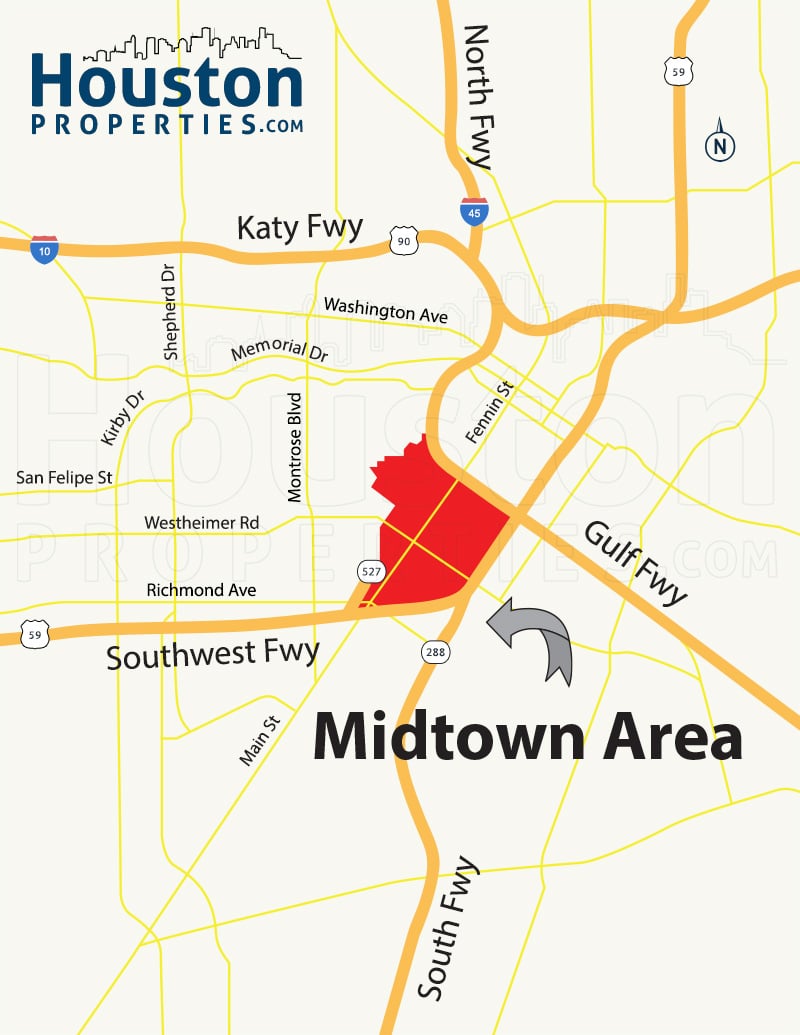
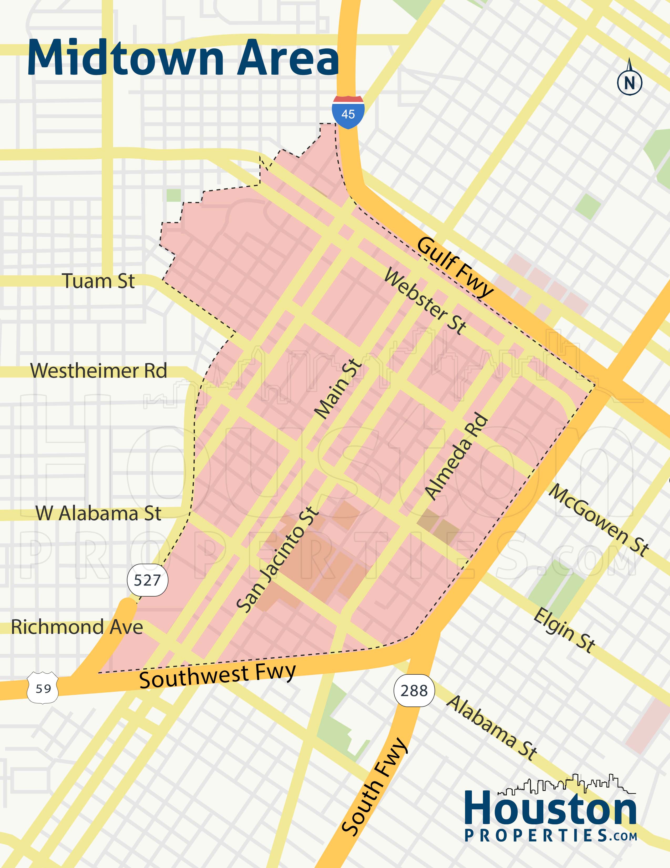
Midtown is one of Houston’s 10 most accessible neighborhoods. Nestled at the corner where the Southwest and Gulf Freeways meet, Midtown permits its residents with comfortable access to the city’s main commercial and business hubs.
Midtown is bordered by the Southwest Freeway (US Highway 59), South Freeway, Gulf Freeway (Interstate 45), and curves through the streets of Cleveland, Baldwin, Pierce, Helena, Valentine, West Webster, Cook, Sutton, Albany to Tuam.
New Midtown Houston Neighborhood Area Map
Midtown Houston Maps: Neighborhood

“Paige and her team are knowledgeable, attentive, responsive, and patient. The HoustonProperties.com team put us into our first dream home, and due to that experience, we’ve returned to them time and again for our real estate needs. While the team’s focus is on completing your deal, their endgame is to ensure your needs are preserved and satisfied.” - Peter McGillivray & Jillian Jopling
Located within Houston’s Inner Loop, Midtown residents are a few blocks away from approximately 180 restaurants, bars, and coffee shops. Many of Midtown’s new construction homes were designed to accommodate and encourage retail activities on the first floors of multi-story buildings.
Midtown also has an excellent reputation in public transportation and bike-ability.
Midtown suffered a great population loss in the past, but through the establishment of the Tax Increment Reinvestment Zone (TIRZ), the neighborhood has seen an increase in townhomes and condominiums, parks, and businesses developments.
Moving around the district is made easy through the MetroRail line that runs through Main Street, and the many bus routes that pass through the area. Midtown Houston attracts people looking for varied dining options, energetic nightlife, and shopping destinations.
Midtown homes for sale prices range from over $100,000 to over $400,000. The area offers some of the most affordable prices per square foot located near Downtown Houston.
Nearby neighborhoods include Museum District, River Oaks, Montrose, Rice Military, and Upper Kirby.
New Midtown Houston Neighborhood Map
The Best Houston Realtor to Sell Your Home

The Houston Properties Team has a well-defined structure based on the individual strengths of each member. Each member is a specialist in their role – which is why our homes sell faster and for more money than average.
Paige Martin, Broker Associate with Keller Williams Realty, and the Houston Properties Team are ranked among the top residential Realtors in the world.
They have been featured on TV and in dozens of publications including The Wall Street Journal, Fortune Magazine, Reuters, Fox News in the Morning, Money Magazine, Houston Business Journal, Houstonia, and Houston Chronicle.
Paige Martin was just ranked as the #5 agent in the world with Keller Williams, completing over $1 Billion in Houston residential real estate sales.

Recent awards include:
– 2022: #1 Residential Real Estate Team by Sales Volume, Houston Business Journal
– 2021: Best Real Estate Teams in America, RealTrends.com
– 2021: Top 100 Women Leaders in Real Estate of 2021
– 2021: America’s Top 100 Real Estate Agents
– 2021: Top Real Estate Team (Houston Properties Team), Houston Business Journal
– 2021: Best Houston Real Estate Team, Best of Reader’s Choice
– 2021: Top Real Estate Team (Houston Properties Team), Houston Business Journal
– 2021: #1 Real Estate Team, Keller Williams Memorial
– 2020: America’s Best Real Estate Teams, Best of America Trends
– 2020: Best Houston Real Estate Team, Best of Reader’s Choice
– 2020: Top Real Estate Team (Houston Properties Team), Houston Business Journal
– 2020: #6 Individual Agent, Keller Williams, Worldwide
– 2020: #1 Individual Agent, Keller Williams, Texas (Top Keller Williams Realtor)
– 2020: #1 Real Estate Team, Keller Williams Memorial
- 2019: Top Residential Realtors in Houston, Houston Business Journal
- 2019: America’s Best Real Estate Agents, RealTrends.com
- 2019: #5 Individual Agent, KW Worldwide
- 2019: #1 Individual Agent, KW Texas
- 2018: #5 Individual Agent, Keller Williams, Worldwide
- 2018: #1 Individual Agent, Keller Williams, Texas
- 2018: #1 Individual Agent, Keller Williams, Houston
- 2018: America’s Best Real Estate Agents, RealTrends.com
- 2018: Top 25 Residential Realtors in Houston, Houston Business Journal
- 2018: Texas’ Most Influential Realtors
- 2017: #1 Individual Agent, Keller Williams, Texas
- 2017: #1 Individual Agent, Keller Williams, Houston
- 2017: #10 Individual Agent, Keller Williams, Worldwide
- 2017: America’s Best Real Estate Agents, RealTrends.com
- 2017: Top 25 Residential Realtors in Houston, Houston Business Journal
- 2017: Texas’ Most Influential Realtors
- 2016: #1 Individual Agent, Keller Williams, Texas
- 2016: #1 Individual Agent, Keller Williams, Houston
- 2016: #20 Individual Agent, Keller Williams, Worldwide
- 2016: Texas’ Most Influential Realtors
- 2016: Top 25 Residential Realtors in Houston, HBJ
- 2016: Five Star Realtor, Featured in Texas Monthly
- 2016: America’s Best Real Estate Agents, RealTrends.com
- 2015: #9 Individual Agent, Keller Williams, United States
- 2015: #1 Individual Agent, Keller Williams, Texas
- 2015: #1 Individual Agent, Keller Williams, Houston
- 2015: America’s Best Real Estate Agents, RealTrends.com
- 2015: Top 25 Residential Realtors in Houston, HBJ
- 2015: Five Star Realtor, Texas Monthly Magazine
- 2014: America’s Best Real Estate Agents, RealTrends.com
- 2014: #1 Individual Agent, Keller Williams Memorial
...in addition to over 318 additional awards.
Paige also serves a variety of non-profits, and civic and community boards. She was appointed by the mayor of Houston to be on the downtown TIRZ board.
Benefits Of Working With The Houston Properties Team

Our team, composed of distinguished and competent Houston luxury realtors, has a well-defined structure based on the individual strengths of each member.
We find the team approach as the most effective way to sell homes. We have dedicated people doing staging, marketing, social media, open houses, and showings. Each Houston Properties Team member is a specialist in their role—which is why our homes sell faster and for more money than average.
The benefits of working with a team include:
- the ability to be in two or three places at one time; a member can handle showings, while another answer calls
- collective time and experience of members
- targeted advice and marketing of agent expert in your area
- competitive advantage by simply having more resources, more ideas, and more perspectives
- a “checks and balances” system; selling and buying a home in Houston is an intensely complex process
- more people addressing field calls and questions from buyers and agents to facilitate a faster, successful sale
- efficient multi-tasking; one agent takes care of inspections and repair work, while another agent focuses on administrative details
- multiple marketing channels using members’ networks
- constant attention: guaranteed focus on your home and your transaction
- lower risk for mistakes. Multiple moving parts increase oversights. A team approach handles these “parts” separately
- flexibility in negotiation and marketing
- better management of document flow
- increased foot traffic through more timely and effective showing schedule coordination; and
- increased sphere of influence and exposure to more potential buyers.
To meet all the award-winning members of the Houston Properties Team, please go here.